Homeowners Earthquake Premium Traces Soil Amplification Study Lag Across California
California homeowners pay roughly $1,000 per year on average for earthquake insurance, but that premium may not reflect the actual shaking risk beneath their foundation. The state's rate filings rely on U.S. Geological Survey (USGS) hazard maps, which include soil amplification factors—how loose sediments amplify seismic waves—but those factors are often missing from actuarial tables. A gap between soil science and insurance pricing has persisted for years, and recent developments in reinsurance and data mandates suggest it may finally be closing.
California Earthquake Premiums Diverge from Soil Science
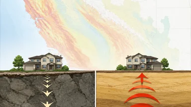
The California Earthquake Authority (CEA), which writes the majority of residential earthquake policies in the state, sets rates based on USGS seismic hazard maps. These maps incorporate soil amplification through a parameter called Vs30—the average shear-wave velocity in the top 30 meters of soil. Yet many carriers use simplified zone-based ratings that ignore site-specific soil conditions. Liquefaction zones, where loose, water-saturated soils behave like liquid during shaking, are often underweighted in actuarial models.
Some estimates suggest that ignoring soil amplification can misprice risk by up to 30 percent for homes on soft sediments. A 2014 working group report from the USGS highlighted that soil effects could double ground motion in some areas. Despite this, rate filings reviewed by the California Department of Insurance rarely include geotechnical data beyond broad ZIP-code classifications.
One reason is cost. Obtaining a Vs30 measurement for a single property can cost several hundred dollars, and insurers argue that the expense outweighs the benefit for a line of business with relatively low take-up rates—only about 10 percent of California homeowners carry earthquake coverage. Others counter that the cost of ignoring soil data is higher: underpriced policies lead to inadequate reserves when a major quake hits.
The divergence is most pronounced in the Central Valley and coastal basins, where deep alluvial soils amplify shaking far more than the bedrock typical of the Sierra foothills. A home in Sacramento might face a similar premium to one in San Francisco, even though soil conditions differ dramatically. Regulators have acknowledged the issue but have not mandated site-specific soil data in filings.
To illustrate the scale of mispricing, consider a hypothetical comparison: a home in the Los Angeles Basin, underlain by thousands of feet of soft sediment, and a home in the Santa Monica Mountains, where bedrock is at or near the surface. Under current zone-based rating, both might be assigned the same risk class despite the basin site experiencing shaking intensity roughly 50 to 100 percent higher during a moderate earthquake. A 2003 study by the Southern California Earthquake Center found that soft-soil sites in the basin experienced peak ground accelerations up to 2.5 times those on nearby rock sites during the 1994 Northridge earthquake. Yet insurance rates do not reflect that differential.
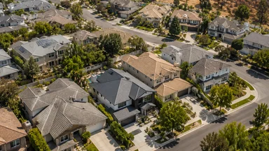
Another challenge is the spatial variability of soil conditions within a single ZIP code. In the San Francisco Bay Area, areas like the Marina district (built on landfill) and Pacific Heights (on bedrock) are in the same postal zone but have vastly different liquefaction and amplification potential. A rate filing that uses ZIP-code-level aggregates will systematically underprice risk in the Marina and overprice it in Pacific Heights. This cross-subsidy is inefficient and can lead to adverse selection, as homeowners on bedrock may drop coverage, leaving a riskier pool.
USGS Maps Update Every Six Years; Ratemaking Delays Further
The USGS releases updated National Seismic Hazard Maps every six years. The 2018 update was the first to fully incorporate the 2014 working group's findings on soil amplification, coding site-response factors directly into the model. But translating those maps into insurance rates takes time. Carriers must file new rates with the California Department of Insurance, a process that can take 12 to 18 months per filing.
Many insurers rely on third-party catastrophe models—from firms like RMS, AIR, or CoreLogic—that incorporate USGS data but apply their own proprietary adjustments. Model validation cycles mean that even the 2018 map updates may not have been fully integrated into pricing until 2022 or later. As of late 2024, some carriers still use pre-2018 hazard curves for parts of their portfolio.
Data integration costs are a cited barrier. Updating a rating engine to accept parcel-level Vs30 inputs requires IT investment and actuarial rework. Smaller regional carriers, which write a disproportionate share of California earthquake policies, often lack the resources to make these changes quickly. The California Department of Insurance reviews filings annually, but does not require carriers to demonstrate that soil amplification is factored in.
The lag means that homeowners on soft soil may be paying the same premium as those on bedrock, despite facing significantly higher risk. A 2023 study by the USGS and the Federal Insurance and Mitigation Administration found that adjusting rates for soil class could reduce cross-subsidies by 15 to 20 percent, but no state has yet adopted such a system.
The six-year cycle itself introduces a structural delay. Even if a carrier immediately adopted the latest USGS map, the map is already up to six years old at the time of adoption. Meanwhile, scientific understanding of soil amplification continues to evolve. For example, the 2023 USGS update (expected to be incorporated into the next map cycle) includes new data on basin effects in the Los Angeles region, where deep sedimentary basins can trap seismic waves and prolong shaking. Carriers that wait for the full map release before updating models will always be behind the science.
Some industry observers argue that the lag is acceptable because the uncertainty in earthquake loss estimation dwarfs the soil amplification effect. Catastrophe models have many moving parts—rupture probability, ground motion attenuation, building vulnerability—and soil is just one variable. But proponents of soil-aware pricing counter that if the variable can be measured and is known to be significant, ignoring it is a form of model error that compounds over time. The 2011 Christchurch earthquake in New Zealand, where soil amplification and liquefaction caused disproportionate damage, is often cited as a cautionary tale.
Tokenized Reinsurance Offers New Capacity for Amplification Risk
Reinsurers have begun exploring alternative capital structures that could fund soil-specific loss models. In July 2026, Oxbridge Re Holdings closed five private placements of tokenized reinsurance securities on the Solana blockchain, raising approximately $7.1 million. These tokenized contracts can reference micro-zones—small geographic areas defined by soil class—allowing investors to take on risk tied to site-specific shaking.
Parametric triggers, which pay out based on measured ground motion rather than actual losses, could be tailored to Vs30 classes. A homeowner on soft soil might have a policy that triggers at a lower magnitude than one on bedrock, reflecting the higher expected damage. This would align premium more closely with risk without requiring complex claims adjustment.
Tokenization also opens capacity to retail investors, potentially increasing the supply of reinsurance for high-risk soil zones. Oxbridge's offerings were oversubscribed, suggesting appetite for granular risk. However, the market is nascent: tokenized reinsurance securities represent less than 1 percent of global reinsurance capital as of mid-2026.
Critics note that tokenized contracts lack the track record of traditional catastrophe bonds. Liquidity is thin, and pricing can be volatile. Still, the ability to reference micro-zones offers a way to fund soil-specific loss models that traditional treaty reinsurance has been slow to adopt.
A key trade-off is between granularity and diversification. Tokenized micro-zone contracts allow investors to take precise bets, but they also concentrate risk in small areas. A single earthquake could trigger many contracts in the same soil class, leading to correlated losses. Traditional catastrophe bonds typically cover broad portfolios that benefit from geographic diversification. Whether tokenized structures can achieve sufficient diversification at the micro-zone level remains an open question. Some proponents suggest that a basket of micro-zone tokens across different soil classes and regions could mimic portfolio effects, but such products are not yet available.
Another concern is basis risk for parametric triggers. A policy that pays out based on ground motion at a nearby seismic station may not perfectly correlate with damage at the insured property, especially if soil conditions differ between the station and the home. Careful station placement and multiple triggers can mitigate this, but it adds complexity. Despite these challenges, the potential for tokenized reinsurance to unlock capital for soil-specific risk is drawing interest from both insurers and fintech firms.
Munich Re Appointment Signals Treaty Focus on Subsoil Perils
Munich Re, one of the world's largest reinsurers, appointed Linda Langenberg as Head of Section Property Treaty Global Clients and Lloyd's in July 2026. The move signals a growing emphasis on treaty pricing that incorporates geotechnical data. Langenberg, who spent over 16 years at Munich Re, now oversees treaty structures for property risks globally.
Treaty pricing has historically relied on broad zone-based models, but that is changing. Reinsurers increasingly ask cedents for Vs30 data at the portfolio level. Some Lloyd's syndicates now require Vs30 measurements for any property risk in seismically active regions. The shift is driven by large losses from recent earthquakes, including the 2023 Turkey-Syria sequence, where soil amplification was a major factor in damage.
For California, this means primary insurers may soon need to provide geotechnical data to secure favorable treaty terms. Carriers that can demonstrate soil-aware underwriting could see lower reinsurance costs, which could flow through to homeowners' premiums. Those that cannot may face higher costs or reduced capacity.
Langenberg's appointment comes amid a broader push by Munich Re to integrate site-response layers into its catastrophe models. The firm has invested in high-resolution Vs30 databases for the United States, with California a priority region. This internal capability could give Munich Re an edge in pricing treaties that reference soil amplification.
The treaty market's demand for geotechnical data creates a classic chicken-and-egg problem. Primary carriers are reluctant to invest in Vs30 data collection without a clear signal that reinsurers will reward it. But reinsurers are hesitant to mandate data until they see that carriers can produce it reliably. Langenberg's appointment suggests that Munich Re is taking a leadership role in breaking this stalemate, but it may take several treaty renewal cycles before the data requirement becomes standard. In the interim, carriers that proactively gather soil data may gain a competitive advantage in treaty negotiations.
Another dimension is the cost of data collection at portfolio scale. A midsize California insurer with 100,000 earthquake policies could spend several million dollars to obtain Vs30 measurements for every property, even using statistical interpolation methods. The return on that investment depends on how much reinsurance costs decline. Early adopters may find that the savings are modest initially, but as more carriers adopt soil-aware pricing, the penalty for not having data may grow. This dynamic mirrors what happened with flood risk data after the 2005 hurricane season, when insurers that lacked granular flood models faced steep reinsurance surcharges.
Aon's Restructured Reinsurance Unit Targets UK-Ireland Soil Gaps
Across the Atlantic, Aon restructured its reinsurance leadership for the UK and Ireland in July 2026, expanding Tom Murray's role to Head of Reinsurance for the region. The move is partly driven by advances in soil amplification studies in the UK, which are more advanced than California's in some respects. The British Geological Survey has mapped Vs30 at high resolution for the entire country, and insurers there have begun incorporating it into flood and earthquake models.
Aon's catastrophe models now include site-response layers that account for local soil conditions. The broker expects to transfer knowledge from the UK-Ireland market to California, where soil data is less integrated. Cross-Atlantic knowledge transfer could accelerate adoption of soil-aware pricing in the U.S.
The UK's advantage stems from a regulatory push: the Prudential Regulation Authority requires insurers to demonstrate that they understand site-specific risks. No equivalent mandate exists in California. Aon's restructuring suggests that the broker sees soil data as a competitive differentiator, particularly for earthquake-prone regions.
For California homeowners, this may mean that their premium will eventually reflect soil class, but the timeline is uncertain. Aon's role as an intermediary between primary carriers and reinsurers could pressure both sides to adopt more granular data.
The UK experience offers a preview of potential challenges. When the PRA first required site-specific risk assessment, many insurers complained about the cost and complexity. Over time, however, the requirement spurred innovation in data collection and modeling. Several UK insurers now use satellite-based remote sensing to estimate Vs30, reducing the need for expensive on-site measurements. Similar technology could be deployed in California, but it would require investment in calibration for the state's diverse geology. The Central Valley, for example, has deep alluvial soils that differ from the glacial till common in the UK, so remote sensing algorithms would need to be adapted.
Aon's restructuring also highlights the importance of broker leadership in pushing data standards. Brokers sit between primary carriers and reinsurers and can facilitate data sharing. If Aon develops a standardized Vs30 data format for California earthquake submissions, it could reduce transaction costs and accelerate adoption. The broker has already done something similar for flood risk in Europe, where it created a common data template for flood hazard submissions. A comparable initiative for seismic soil data could be a game-changer.
Policymakers Face Hard Choices on Data Mandates
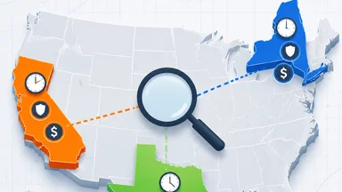
Policymakers in California have so far avoided mandating soil disclosure in insurance transactions. A 2023 bill that would have required insurers to consider Vs30 in rate filings stalled in committee. The California Department of Insurance has held workshops on the topic but has not proposed formal rulemaking. The CEA offers premium discounts for seismic retrofits, but not for providing soil data.
In contrast, New York City has begun addressing building risks through public disclosure. A July 2026 press conference with Mayor Zohran Kwame Mamdani and city officials discussed structurally compromised buildings, highlighting the role of soil conditions in foundation stability. While New York faces less seismic risk, the transparency approach could serve as a model for California.
Industry groups argue that mandates would increase compliance costs and reduce competition. Consumer advocates counter that without mandates, homeowners have no way to know whether their premium reflects actual risk. The tension mirrors debates in flood insurance, where FEMA's flood maps are often criticized for being outdated.
One compromise would be a voluntary soil-rating system, similar to energy efficiency labels, that homeowners could use to shop for coverage. The USGS already provides a free online tool that returns Vs30 for any U.S. address. But without insurer adoption, the tool remains a curiosity rather than a pricing input.
Another policy lever is to require insurers to disclose whether they use soil amplification data in their rating algorithms. This would not mandate the data's use, but it would allow consumers to compare carriers on this dimension. A disclosure requirement could be implemented through the California Department of Insurance's rate filing process, with minimal administrative burden. Some consumer groups have advocated for this approach as a first step toward full transparency. However, insurers have resisted, arguing that disclosure could mislead consumers if they interpret the lack of soil data as a sign of inadequate coverage.
The CEA itself could take a leadership role by incorporating Vs30 into its own rating structure. As the largest writer of earthquake insurance in the state, CEA rate changes would have an outsized impact. The authority has been cautious, partly because its rates must be approved by the California Department of Insurance and partly because of concerns about affordability. If CEA were to introduce soil-based rate differentials, some homeowners on soft soil would see premium increases, potentially reducing take-up rates. But the authority could offset this with discounts for retrofits or by phasing in changes gradually. A 2025 study by the RAND Corporation suggested that a phased approach could reduce political blowback while still improving risk alignment.
Homeowners Can Check Their Soil Class Before Renewal
Homeowners can take steps to understand their soil class before their next renewal. The USGS web tool at earthquake.usgs.gov/ws/ provides Vs30 values for any address in the United States. By entering their location, a homeowner can see whether they are on soft soil (Vs30 below 360 m/s) or hard rock (Vs30 above 760 m/s). This information can be compared with the insurer's quoted rate, if available.
Requesting a geotechnical addendum from the carrier is another option. Some insurers will provide soil class information upon request, though they are not required to. Homeowners can also shop among CEA-qualified insurers, which must use CEA-approved rates but may offer different discounts.
For those considering a retrofit, the CEA offers discounts for bolting foundations and bracing water heaters, but not for soil-based adjustments. Advocacy groups like the United Policyholders suggest asking agents whether the carrier uses site-specific data in its rating algorithm. The answer may reveal whether the premium reflects actual risk.
Ultimately, the gap between soil science and earthquake premiums is narrowing, but slowly. Homeowners who educate themselves about their soil class can make more informed decisions, even as the industry catches up.
For homeowners who discover they are on soft soil, there are additional steps beyond checking premiums. They can consider purchasing a policy with a lower deductible, since the probability of a claim is higher. They can also invest in geotechnical engineering to assess liquefaction potential and foundation vulnerability. In some cases, homeowners have successfully negotiated lower premiums by providing their insurer with a geotechnical report showing that their home's foundation is designed for soft soil conditions. While such negotiations are rare, they are becoming more common as awareness grows. Homeowners should document their soil class and keep records of any communications with their insurer, as this information could be valuable if they need to challenge a rate increase.
This article is for informational purposes only and does not constitute professional advice. Homeowners should consult a licensed insurance agent or geotechnical engineer for personalized guidance.